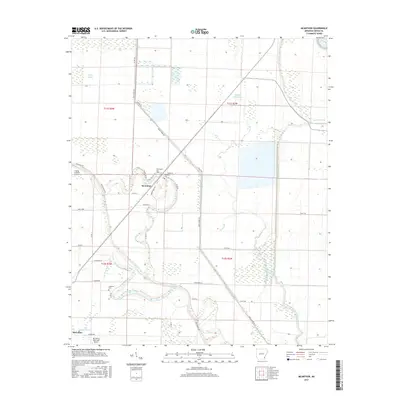
2017 Map of McArthur
USGS Topo · Published 2017About this map
The settlement of McArthur sits at the heart of this Desha County landscape, defined by a complex network of bayous and engineered drainage canals typical of the Arkansas Delta. The winding path of Coon Bayou and Middle Coon Bayou intersects with modern straight-line features like Canal Number 16 and Canal Number 43, illustrating the long-term efforts to manage the wetlands for agricultural use. To the south, the northern outskirts of McGehee appear near the Mc Gehee Municipal Airport. For those researching local history or genealogy, several burial sites are documented across the plain, including Palestine Cem, Warrington Cem, and McArthur Cem. The map reveals a transition from the irregular, water-carved terrain along Opossum Fork to the strictly gridded section lines and agricultural roads that now dominate the region.
Find a feature on this map
41 named features on this map. Tap any name to fly to it.
Don’t see what you’re looking for? This feature index may not catch every label — zoom into the map to look around manually.
Map Details
Editions of this 2017 McArthur Map
This is the sole edition of this map. No revisions or reprints were ever made.
Other maps of this area

1933 · Lamont
USGS Topo · 1:62,500

1935 · Red Fork
USGS Topo · 1:62,500

1936 · McGehee
USGS Topo · 1:62,500

1937 · McGehee
USGS Topo · 1:62,500

1939 · Big Island
USGS Topo · 1:62,500

1939 · Lamont
USGS Topo · 1:62,500

1953 · Greenwood
USGS Topo · 1:250,000

1955 · McGehee
USGS Topo · 1:62,500

1956 · Greenwood
USGS Topo · 1:250,000
1969 · Winchester
USGS Topo · 1:24,000