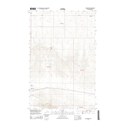
2014 Map of McCabe West
USGS Topo · Published 2014About this map
Sugar Top Hill rises above the rolling plains of Roosevelt County, anchoring a landscape shaped by rural infrastructure and agriculture in the early twenty-first century. The settlement of McCabe occupies the northeastern corner of the sheet, connected to the surrounding countryside by a network of local routes including McCabe Rd and CR-2052. In the southern portion of the quadrangle, the high-speed transit of Us-2 runs parallel to the winding course of Clover Cr, while the Big Sky Field Airport provides a localized aviation hub for the region. The map reveals the systematic Public Land Survey System boundaries, such as t29n r56e and t28n r56e, which dictate the orderly grid of section lines and gravel roads like Sugar Top Rd that define the ranching and farming economy of this eastern Montana territory.
Find a feature on this map
17 named features on this map. Tap any name to fly to it.
Don’t see what you’re looking for? This feature index may not catch every label — zoom into the map to look around manually.
Map Details
Editions of this 2014 McCabe West Map
This is the sole edition of this map. No revisions or reprints were ever made.
Other maps of this area

1914 · Homestead
USGS Topo · 1:62,500

1949 · Johnson Lake
USGS Topo · 1:24,000
1950 · Johnson Lake
USGS Topo · 1:24,000

1954 · Wolf Point
USGS Topo · 1:250,000

1958 · Wolf Point
USGS Topo · 1:250,000

1969 · Cedar Coulee
USGS Topo · 1:24,000
1969 · Culbertson
USGS Topo · 1:24,000

1969 · Three Buttes
USGS Topo · 1:24,000

1969 · Dugout Creek
USGS Topo · 1:24,000

1982 · Culbertson
USGS Topo · 1:100,000