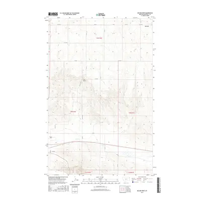
2017 Map of McCabe West
USGS Topo · Published 2017About this map
McCabe sits in the northeastern corner of this Roosevelt County landscape, serving as a primary point of reference in an area defined by agricultural land and prairie drainage. The terrain is marked by the prominence of Sugar Top Hill, which rises above a network of section roads like Sugar Top Rd and Co Rd 1019. Hydrological patterns are defined by the winding course of Clover Cr through the southern sections and Sheep Cr to the west, illustrating the natural water management of the High Plains. The presence of Big Sky Field in the southwestern quadrant indicates the intersection of industry and the open range, while the rectilinear grid of routes such as McCabe Rd and Hwy 496 reflects the enduring impact of the Public Land Survey System on Montana's rural development.
Find a feature on this map
23 named features on this map. Tap any name to fly to it.
Don’t see what you’re looking for? This feature index may not catch every label — zoom into the map to look around manually.
Map Details
Editions of this 2017 McCabe West Map
This is the sole edition of this map. No revisions or reprints were ever made.
Other maps of this area

1914 · Homestead
USGS Topo · 1:62,500

1949 · Johnson Lake
USGS Topo · 1:24,000
1950 · Johnson Lake
USGS Topo · 1:24,000

1954 · Wolf Point
USGS Topo · 1:250,000

1958 · Wolf Point
USGS Topo · 1:250,000

1969 · Cedar Coulee
USGS Topo · 1:24,000
1969 · Culbertson
USGS Topo · 1:24,000

1969 · Three Buttes
USGS Topo · 1:24,000

1969 · Dugout Creek
USGS Topo · 1:24,000

1982 · Culbertson
USGS Topo · 1:100,000