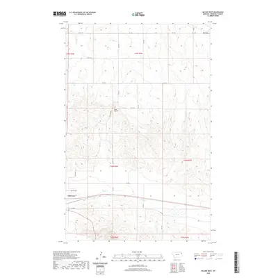
2020 Map of McCabe West
USGS Topo · Published 2020About this map
Culbertson serves as a primary geographic anchor at the edge of this Montana landscape, where the northern plains meet the drainage systems of the Missouri River valley. The terrain is defined by the elevation of Sugar Top Hill and the seasonal flows of Clover Cr and Sheep Cr. This 2020 survey illustrates a sparsely populated region primarily organized by a grid of rural routes such as McCabe Rd and Sugar Top Rd, which connect remote homesteads and agricultural tracts. The small settlement of McCabe appears in the northeast, while the presence of Big Sky Field suggests the continuing importance of aviation and open-space utility in Roosevelt County. The map provides a contemporary view of the intersection between traditional township-and-range boundaries and the modern road network, including Hwy 496.
Find a feature on this map
23 named features on this map. Tap any name to fly to it.
Don’t see what you’re looking for? This feature index may not catch every label — zoom into the map to look around manually.
Map Details
Editions of this 2020 McCabe West Map
This is the sole edition of this map. No revisions or reprints were ever made.
Other maps of this area

1914 · Homestead
USGS Topo · 1:62,500

1949 · Johnson Lake
USGS Topo · 1:24,000
1950 · Johnson Lake
USGS Topo · 1:24,000

1954 · Wolf Point
USGS Topo · 1:250,000

1958 · Wolf Point
USGS Topo · 1:250,000

1969 · Cedar Coulee
USGS Topo · 1:24,000
1969 · Culbertson
USGS Topo · 1:24,000

1969 · Three Buttes
USGS Topo · 1:24,000

1969 · Dugout Creek
USGS Topo · 1:24,000

1982 · Culbertson
USGS Topo · 1:100,000