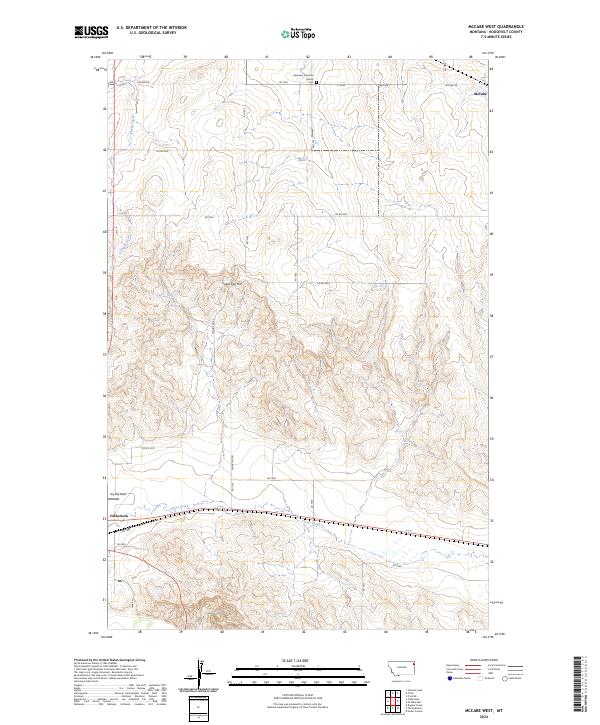
2024 Map of McCabe West
USGS Topo · Published 2024About this map
Ebenezer Lutheran Church and its adjacent Cem stand as central landmarks in this high-plains landscape of Roosevelt County. The map documents the rural distribution of the eastern Montana countryside, where isolated settlements like McCabe and the larger center of Culbertson are linked by a network of local roads such as McCabe Rd and Co Rd 2054. The terrain is characterized by the modest elevation of Sugar Top Hill and the drainage patterns of Sheep Creek and Clover Creek. A notable modern landmark, Big Sky Field, appears near the town of Culbertson. This contemporary survey by the U.S. Geological Survey provides a detailed view of the regional infrastructure and land divisions across townships like T29N R56E, useful for those tracing family ties to the area's enduring Lutheran community or local land use history.
Find a feature on this map
24 named features on this map. Tap any name to fly to it.
Don’t see what you’re looking for? This feature index may not catch every label — zoom into the map to look around manually.
Map Details
Editions of this 2024 McCabe West Map
This is the sole edition of this map. No revisions or reprints were ever made.
Other maps of this area

1914 · Homestead
USGS Topo · 1:62,500

1949 · Johnson Lake
USGS Topo · 1:24,000
1950 · Johnson Lake
USGS Topo · 1:24,000

1954 · Wolf Point
USGS Topo · 1:250,000

1958 · Wolf Point
USGS Topo · 1:250,000

1969 · Cedar Coulee
USGS Topo · 1:24,000
1969 · Culbertson
USGS Topo · 1:24,000

1969 · Three Buttes
USGS Topo · 1:24,000

1969 · Dugout Creek
USGS Topo · 1:24,000

1982 · Culbertson
USGS Topo · 1:100,000