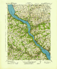
1943 Map of McCalls Ferry
USGS Topo · Published 1943About this map
The Susquehanna River dominates this mid-century landscape, serving as the industrial and geographical boundary between York County and Lancaster County. Along the eastern shore, the Pennsylvania RR and specialized stops like Shenks Ferry Sta and Creswell Sta highlight the river's role as a primary transportation corridor. Inland, the terrain is defined by a dense network of small farming communities and educational landmarks such as the Mylin School and Prospect Hill School.
Find a feature on this map
126 named features on this map. Tap any name to fly to it.
Don’t see what you’re looking for? This feature index may not catch every label — zoom into the map to look around manually.
Map Details
Editions of this 1943 McCalls Ferry Map
2 editions found

Other maps of this area

1900 · Havre De Grace
USGS Topo · 1:62,500

1900 · Parkton
USGS Topo · 1:62,500

1901 · Belair
USGS Topo · 1:62,500

1902 · Parkton
USGS Topo · 1:62,500

1902 · Lancaster
USGS Topo · 1:62,500

1904 · Lancaster
USGS Topo · 1:62,500

1906 · New Holland
USGS Topo · 1:62,500

1908 · Middletown
USGS Topo · 1:62,500

1908 · New Holland
USGS Topo · 1:62,500

1908 · York
USGS Topo · 1:62,500
Featured Places
- West Lampeter Township, PA
- Willow Street, West Lampeter Township
- Millersville, PA
- Pequea, Conestoga Township
- Conestoga Township, PA