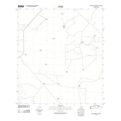
2010 Map of McCampbell Ranch
USGS Topo · Published 2010About this map
Mc Campbell Ranch and a network of named windmills define this ranching landscape in Jim Hogg County. The terrain is structured by a series of isolated water points essential for livestock, including Martinez Windmill, Georgies Windmill, and San Francisco Windmill. These features indicate the vital role of groundwater management in this part of South Texas, where natural watercourses like Arroyo de Magueyes and Arroyo del Gato provide intermittent drainage.
Find a feature on this map
22 named features on this map. Tap any name to fly to it.
Don’t see what you’re looking for? This feature index may not catch every label — zoom into the map to look around manually.
Map Details
Editions of this 2010 McCampbell Ranch Map
This is the sole edition of this map. No revisions or reprints were ever made.
Other maps of this area

1939 · Bruni
USGS Topo · 1:62,500

1939 · Randado
USGS Topo · 1:62,500

1940 · Randado
USGS Topo · 1:62,500

1956 · Laredo
USGS Topo · 1:250,000

1967 · Hebbronville SE
USGS Topo · 1:24,000

1967 · Hebbronville
USGS Topo · 1:24,000

1972 · Armstrong Ranch
USGS Topo · 1:24,000
1972 · San Pablo Ranch
USGS Topo · 1:24,000

1972 · Bruni SE
USGS Topo · 1:24,000
1972 · Alta Vista Ranch SW
USGS Topo · 1:24,000