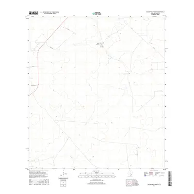
2016 Map of McCampbell Ranch
USGS Topo · Published 2016About this map
McCampbell Ranch stands as a central landmark in this portion of Jim Hogg County, reflecting the deep ranching heritage of South Texas. The landscape is defined by its subtle relief and intermittent drainage systems, most notably the seasonal watercourses of Arroyo del Gato, Arroyo de Magueyes, and Arroyo los Palos. These arroyos indicate the natural water movement across the brush country terrain, which is otherwise navigated by a sparse network of local roads. The inclusion of Fm 1017 and several named tracks like La Chancaca Rd and Wied Rd documents the essential connectivity between remote ranch properties in the early 21st century. This survey captures a specific moment in the rural management of the region, where family-named landmarks and long-established land divisions continue to shape the local geography.
Find a feature on this map
10 named features on this map. Tap any name to fly to it.
Don’t see what you’re looking for? This feature index may not catch every label — zoom into the map to look around manually.
Map Details
Editions of this 2016 McCampbell Ranch Map
This is the sole edition of this map. No revisions or reprints were ever made.
Other maps of this area

1939 · Bruni
USGS Topo · 1:62,500

1939 · Randado
USGS Topo · 1:62,500

1940 · Randado
USGS Topo · 1:62,500

1956 · Laredo
USGS Topo · 1:250,000

1967 · Hebbronville SE
USGS Topo · 1:24,000

1967 · Hebbronville
USGS Topo · 1:24,000

1972 · Armstrong Ranch
USGS Topo · 1:24,000
1972 · San Pablo Ranch
USGS Topo · 1:24,000

1972 · Bruni SE
USGS Topo · 1:24,000
1972 · Alta Vista Ranch SW
USGS Topo · 1:24,000