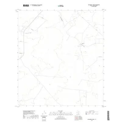
2019 Map of McCampbell Ranch
USGS Topo · Published 2019About this map
McCampbell Ranch sits in the brush country of Jim Hogg County, serving as the primary named landmark in this landscape of intermittent drainages and ranch access roads. The terrain is defined by seasonal watercourses, with Arroyo del Gato and Arroyo de Magueyes cutting through the sandy soil. Modern infrastructure is represented by FM 1017, which provides the main north-south transit corridor across these south Texas plains. The network of local roads including Barnhart Rd and Wied Rd reflects the large-acreage landholding patterns typical of the region. Near the ranch headquarters, Arroyo los Palos marks a natural focal point in a territory where water management is central to the local economy and settlement history.
Find a feature on this map
10 named features on this map. Tap any name to fly to it.
Don’t see what you’re looking for? This feature index may not catch every label — zoom into the map to look around manually.
Map Details
Editions of this 2019 McCampbell Ranch Map
This is the sole edition of this map. No revisions or reprints were ever made.
Other maps of this area

1939 · Bruni
USGS Topo · 1:62,500

1939 · Randado
USGS Topo · 1:62,500

1940 · Randado
USGS Topo · 1:62,500

1956 · Laredo
USGS Topo · 1:250,000

1967 · Hebbronville SE
USGS Topo · 1:24,000

1967 · Hebbronville
USGS Topo · 1:24,000

1972 · Armstrong Ranch
USGS Topo · 1:24,000
1972 · San Pablo Ranch
USGS Topo · 1:24,000

1972 · Bruni SE
USGS Topo · 1:24,000
1972 · Alta Vista Ranch SW
USGS Topo · 1:24,000