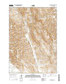
2014 Map of McCarthy Ridge
USGS Topo · Published 2014About this map
The high desert landscape of eastern Oregon is defined here by the drainage networks of Dry Gulch and the prominent McCarthy Ridge. In this arid portion of Malheur County, water management is the primary marker of human presence, seen in several high-elevation catchments such as the McCarthy Ridge Reservoir, Tub Mountain Reservoir, and W Tub Mountain Reservoir. These reservoirs, along with numerous named seeps like Mud Spring, Beirman Spring, and McDowell Spring, supported the region's ranching and livestock operations. A significant historical corridor, the Old Oregon Trl, cuts through the eastern portion of the map, tracing a route through Moores Hollow and around the base of Tub Mtn. The transport network is further filled out by local tracks such as Lockett Rd and McCarthy Ridge Rd, which follow the natural contours of the ridges and canyons.
Find a feature on this map
28 named features on this map. Tap any name to fly to it.
Don’t see what you’re looking for? This feature index may not catch every label — zoom into the map to look around manually.
Map Details
Editions of this 2014 McCarthy Ridge Map
This is the sole edition of this map. No revisions or reprints were ever made.
Other maps of this area

1950 · Jamieson
USGS Topo · 1:62,500

1951 · Moores Hollow
USGS Topo · 1:62,500

1951 · Huntington
USGS Topo · 1:62,500

1952 · Olds Ferry
USGS Topo · 1:24,000

1952 · Olds Ferry
USGS Topo · 1:62,500

1955 · Baker
USGS Topo · 1:250,000

1959 · Baker
USGS Topo · 1:250,000

1980 · Brogan
USGS Topo · 1:100,000
1987 · Willowcreek
USGS Topo · 1:24,000
1988 · Birch Creek Meadow
USGS Topo · 1:24,000