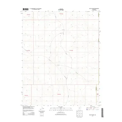
2013 Map of McCloy Ranch
USGS Topo · Published 2013About this map
McCloy Ranch sits at the heart of this rangeland landscape in northeastern New Mexico, where the high plains meet the transition between Harding and Quay counties. The map documents a sparsely populated ranching territory characterized by a network of rural routes, including Nara Visa Rd and Rosebud Rd, which trace the gentle topographic undulations of the region. The layout of these roads, such as Co Road G and Co Road I-1, suggests the enduring importance of large-scale land holdings and the infrastructure required to manage them in a semi-arid environment. This 2013 survey provides a detailed record of the township and range divisions, illustrating how the Public Land Survey System continues to define the spatial organization of this western terrain.
Find a feature on this map
15 named features on this map. Tap any name to fly to it.
Don’t see what you’re looking for? This feature index may not catch every label — zoom into the map to look around manually.
Map Details
Editions of this 2013 McCloy Ranch Map
This is the sole edition of this map. No revisions or reprints were ever made.
Other maps of this area

1954 · Tucumcari
USGS Topo · 1:250,000

1958 · Tucumcari
USGS Topo · 1:250,000

1966 · Rosebud
USGS Topo · 1:24,000

1966 · Ione
USGS Topo · 1:24,000

1966 · Cherokee Valley
USGS Topo · 1:24,000

1966 · Lockney
USGS Topo · 1:24,000

1966 · Mc Carty Ranch
USGS Topo · 1:24,000

1966 · Mc Cloy Ranch
USGS Topo · 1:24,000

1969 · Gallegos NE
USGS Topo · 1:24,000
1969 · Fuentes Ranch
USGS Topo · 1:24,000