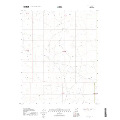
2020 Map of McCloy Ranch
USGS Topo · Published 2020About this map
McCloy Ranch sits within a landscape defined by the convergence of Union, Harding, and Quay counties. This 2020 survey documents a high plains environment where human presence is primarily marked by a sparse network of county roads. The alignment of Highwell Rd, Co Rd G, and Co Rd I-1 illustrates the grid-based settlement and ranching infrastructure typical of northeastern New Mexico. The map provides a detailed view of the terrain and township boundaries, such as t17n r33e and t18n r33e, which underpin the region's land management. The absence of dense population centers highlights the isolation and operational scale of modern ranching in this corner of the state.
Find a feature on this map
14 named features on this map. Tap any name to fly to it.
Don’t see what you’re looking for? This feature index may not catch every label — zoom into the map to look around manually.
Map Details
Editions of this 2020 McCloy Ranch Map
This is the sole edition of this map. No revisions or reprints were ever made.
Other maps of this area

1954 · Tucumcari
USGS Topo · 1:250,000

1958 · Tucumcari
USGS Topo · 1:250,000

1966 · Rosebud
USGS Topo · 1:24,000

1966 · Ione
USGS Topo · 1:24,000

1966 · Cherokee Valley
USGS Topo · 1:24,000

1966 · Lockney
USGS Topo · 1:24,000

1966 · Mc Carty Ranch
USGS Topo · 1:24,000

1966 · Mc Cloy Ranch
USGS Topo · 1:24,000

1969 · Gallegos NE
USGS Topo · 1:24,000
1969 · Fuentes Ranch
USGS Topo · 1:24,000