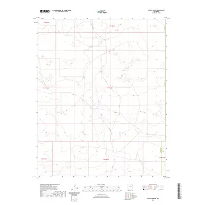
2023 Map of McCloy Ranch
USGS Topo · Published 2023About this map
High plains ranching country in Northeast New Mexico dominates this landscape, where the vast open spaces of the McCloy Ranch area are defined by a sparse network of section roads and cattle trails. The terrain is marked by subtle changes in elevation, with Highwell Rd cutting a diagonal path across the central portion of the survey. Essential ranching infrastructure is captured through the naming of local routes such as Co Rd G, Co Rd I, and their secondary branches. The map highlights the administrative transition at the southern and eastern edges, where the Harding Co line meets Quay Co, a point of interest for researchers tracking historical land boundaries and property ownership in this quiet corner of the state.
Find a feature on this map
14 named features on this map. Tap any name to fly to it.
Don’t see what you’re looking for? This feature index may not catch every label — zoom into the map to look around manually.
Map Details
Editions of this 2023 McCloy Ranch Map
This is the sole edition of this map. No revisions or reprints were ever made.
Other maps of this area

1954 · Tucumcari
USGS Topo · 1:250,000

1958 · Tucumcari
USGS Topo · 1:250,000

1966 · Rosebud
USGS Topo · 1:24,000

1966 · Ione
USGS Topo · 1:24,000

1966 · Cherokee Valley
USGS Topo · 1:24,000

1966 · Lockney
USGS Topo · 1:24,000

1966 · Mc Carty Ranch
USGS Topo · 1:24,000

1966 · Mc Cloy Ranch
USGS Topo · 1:24,000

1969 · Gallegos NE
USGS Topo · 1:24,000
1969 · Fuentes Ranch
USGS Topo · 1:24,000