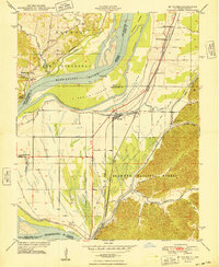
1948 Map of McClure
USGS Topo · Published 1948About this map
The Mississippi River dominates this mid-century landscape, carving a complex boundary between Missouri and Illinois through a network of chutes and islands. On the Illinois side, the settlement of McClure serves as a central hub, situated near the intersection of the Missouri Pacific and Illinois Central railroads. The map captures a vital transit corridor where rail lines and the Big Inch pipeline traverse the bottomlands. To the east, the terrain rises into the Shawnee National Forest, where deep drainages like Dongola Hollow and Happy Hollow cut through the hills.
Find a feature on this map
40 named features on this map. Tap any name to fly to it.
Don’t see what you’re looking for? This feature index may not catch every label — zoom into the map to look around manually.
Map Details
Editions of this 1948 McClure Map
This is the sole edition of this map. No revisions or reprints were ever made.
Other maps of this area

1920 · Jonesboro
USGS Topo · 1:62,500

1922 · Cape Girardeau
USGS Topo · 1:62,500

1923 · Jonesboro
USGS Topo · 1:62,500

1924 · Cape Girardeau
USGS Topo · 1:62,500

1934 · Thebes
USGS Topo · 1:62,500

1934 · Morley
USGS Topo · 1:62,500

1939 · Morley
USGS Topo · 1:62,500

1939 · Thebes
USGS Topo · 1:62,500

1947 · Jonesboro
USGS Topo · 1:62,500

1947 · Mc Clure
USGS Topo · 1:24,000