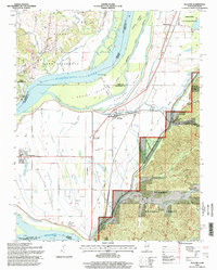
1996 Map of McClure
USGS Topo · Published 1998About this map
The Mississippi River dominates this mid-1990s geography of the Illinois-Missouri border, carving a wide path that creates Devils Island and the Picayune Chute. Along the eastern bank in Illinois, a complex network of drainage features like Main Ditch and Big Ditch underscores the region's history of managing bottomlands for agriculture and settlement. The Illinois Central RR runs parallel to the river, connecting small communities like McClure and Reynoldsville that sit protected behind an extensive Levee system.
Find a feature on this map
40 named features on this map. Tap any name to fly to it.
Don’t see what you’re looking for? This feature index may not catch every label — zoom into the map to look around manually.
Map Details
Editions of this 1996 McClure Map
This is the sole edition of this map. No revisions or reprints were ever made.
Other maps of this area

1920 · Jonesboro
USGS Topo · 1:62,500

1922 · Cape Girardeau
USGS Topo · 1:62,500

1923 · Jonesboro
USGS Topo · 1:62,500

1924 · Cape Girardeau
USGS Topo · 1:62,500

1934 · Thebes
USGS Topo · 1:62,500

1934 · Morley
USGS Topo · 1:62,500

1939 · Morley
USGS Topo · 1:62,500

1939 · Thebes
USGS Topo · 1:62,500

1947 · Jonesboro
USGS Topo · 1:62,500

1947 · Mc Clure
USGS Topo · 1:24,000