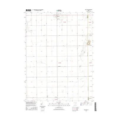
2016 Map of McClure
USGS Topo · Published 2016About this map
McClure anchors this agricultural landscape in Henry County, where the township grid is deeply etched by a network of drainage and historic county roads. The terrain is defined by the subtle eastward flow of Beaver Cr and its tributaries, including Little Beaver Cr and Hammer Cr, which wind through the flat farmland. Small, localized pockets of history are preserved in several rural cemeteries such as Richfield Cem and Angell Cem, which reflect the early settlement patterns of Damascus Township. Further south, the community of Westhope and landmarks like Peace Church and Saint Johns Lutheran Cem demonstrate the long-standing social and religious centers of this rural Ohio region. The map also captures the clear demarcation of the Henry and Wood county line, illustrating how administrative boundaries bisect the natural and man-made features of the Black Swamp area.
Find a feature on this map
78 named features on this map. Tap any name to fly to it.
Don’t see what you’re looking for? This feature index may not catch every label — zoom into the map to look around manually.
Map Details
Editions of this 2016 McClure Map
This is the sole edition of this map. No revisions or reprints were ever made.
Other maps of this area

1908 · Ottawa
USGS Topo · 1:62,500

1908 · Napoleon
USGS Topo · 1:62,500

1909 · Mc Clure
USGS Topo · 1:62,500

1935 · Grand Rapids
USGS Topo · 1:24,000

1940 · Grand Rapids
USGS Topo · 1:31,680
1952 · Grand Rapids
USGS Topo · 1:24,000

1953 · Fort Wayne
USGS Topo · 1:250,000

1956 · Fort Wayne
USGS Topo · 1:250,000

1956 · Toledo
USGS Topo · 1:250,000
1958 · Grand Rapids
USGS Topo · 1:24,000