
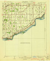
1940 Map of Grand Rapids
USGS Topo · Published 1940About this map
The Maumee River defines the southern edge of this landscape, its waters divided by numerous landforms including Missionary Island, Butler Island, and Sheets Island. This mid-century survey illustrates a transition in local transportation, as the defunct Wabash Railroad route sits north of the active Chicago and Erie Railroad. The map reveals a highly structured drainage system of ditches serving the agricultural lands around Neapolis and the settlement of Grand Rapids. Notable for local historians is the Twelvemile Reservation Boundary, which cuts across the grid, reflecting older jurisdictional lines. Community landmarks such as Salem Ch, Providence Ch, and the Toledo Welfare Farm are clearly marked, alongside the remains of the Napoleon Canal tracing the northern riverbank.
Find a feature on this map
27 named features on this map. Tap any name to fly to it.
Don’t see what you’re looking for? This feature index may not catch every label — zoom into the map to look around manually.
Map Details
Editions of this 1940 Grand Rapids Map
2 editions found
Other maps of this area

1900 · Toledo
USGS Topo · 1:62,500

1901 · Bowling Green
USGS Topo · 1:62,500

1903 · Bowling Green
USGS Topo · 1:62,500

1909 · Mc Clure
USGS Topo · 1:62,500

1911 · Swanton
USGS Topo · 1:62,500

1914 · Swanton
USGS Topo · 1:62,500

1935 · Grand Rapids
USGS Topo · 1:24,000

1935 · Whitehouse
USGS Topo · 1:24,000

1935 · Maumee
USGS Topo · 1:24,000
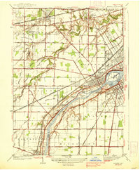
1938 · Maumee
USGS Topo · 1:31,680