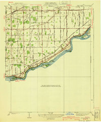
1940 Map of Grand Rapids
USGS Topo · Published 1940About this map
The Maumee River defines the southern boundary of this survey, carving a path through Lucas and Wood counties and past a series of riverine landmarks including Missionary Island and Sheets Island. Along its banks, the remnants of the Miami and Erie Canal run parallel to the water, passing near the Providence Dam and the settlement of Grand Rapids. This area serves as a primary corridor for transportation, featuring the St Louis and Toledo RR following the river’s curve while the Wabash RR cuts across the northern landscape near Neapolis. Farther inland, the terrain is partitioned by an extensive network of drainage ditches—such as Blue Creek and Otter Creek—and rural roads named for local families. Landmarks like the Toledo Welfare Farm and Salem Ch anchor the agricultural community during this mid-century period.
Find a feature on this map
35 named features on this map. Tap any name to fly to it.
Don’t see what you’re looking for? This feature index may not catch every label — zoom into the map to look around manually.
Map Details
Editions of this 1940 Grand Rapids Map
2 editions found

Other maps of this area

1900 · Toledo
USGS Topo · 1:62,500

1901 · Bowling Green
USGS Topo · 1:62,500

1903 · Bowling Green
USGS Topo · 1:62,500

1909 · Mc Clure
USGS Topo · 1:62,500

1911 · Swanton
USGS Topo · 1:62,500

1914 · Swanton
USGS Topo · 1:62,500

1935 · Grand Rapids
USGS Topo · 1:24,000

1935 · Whitehouse
USGS Topo · 1:24,000

1935 · Maumee
USGS Topo · 1:24,000
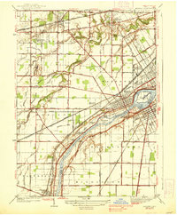
1938 · Maumee
USGS Topo · 1:31,680