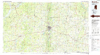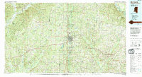
1994 Map of McComb
USGS Topo · Published 1994About this map
The Illinois Central Railroad corridor anchors this 1994 survey of the southern Mississippi borderlands, connecting the major centers of McComb, Magnolia, and Summit. This rail-driven settlement pattern is contrasted by the wooded expanse of the Homochitto National Forest and Homochitto State Wildlife Management Area to the west, where the Homochitto River and its forks carve through the landscape. The map reveals a dense network of rural communities such as Holmesville, Fernwood, and Chatawa, often identified by their local institutions like Southwest Mississippi Jr College or Percy Quin State Park. For the family historian, the sheet is an exceptional record of localized geography, naming dozens of rural landmarks including Zion Hill Ch and Pricedale Cem. Numerous creeks and rivers, including the Bogue Chitto River and the Amite River, define the drainage of this river-rich territory just north of the Louisiana line.
Find a feature on this map
201 named features on this map. Tap any name to fly to it.
Don’t see what you’re looking for? This feature index may not catch every label — zoom into the map to look around manually.
Map Details
Editions of this 1994 McComb Map
This is the sole edition of this map. No revisions or reprints were ever made.