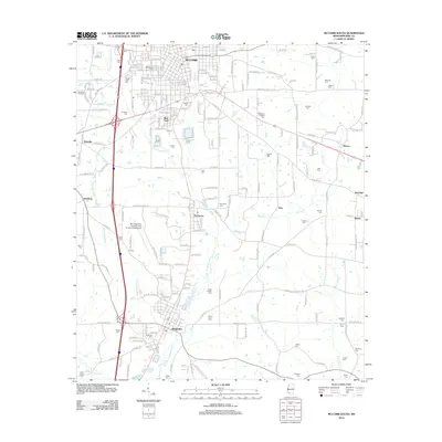
2012 Map of McComb South
USGS Topo · Published 2012About this map
The Little Tangipahoa River and Minnehaha River define the north-south drainage of this Pike County landscape, connecting the regional centers of McComb and Magnolia. The 2012 survey illustrates the urban expansion of McComb southward into Bear Town, balanced by industrial footprints like the McComb Oil Field to the west. A significant concentration of family and community burial sites, including Hollywood Cem, Andrews Cem, and the Ansel Prewitt Cem, provides a detailed record of local genealogy and settlement patterns.
Find a feature on this map
86 named features on this map. Tap any name to fly to it.
Don’t see what you’re looking for? This feature index may not catch every label — zoom into the map to look around manually.
Map Details
Editions of this 2012 McComb South Map
This is the sole edition of this map. No revisions or reprints were ever made.
Other maps of this area

1953 · Natchez
USGS Topo · 1:250,000

1956 · Natchez
USGS Topo · 1:250,000

1959 · Natchez
USGS Topo · 1:250,000
1972 · Osyka
USGS Topo · 1:24,000

1972 · Auburn
USGS Topo · 1:24,000

1972 · Pricedale
USGS Topo · 1:24,000

1972 · McComb South
USGS Topo · 1:24,000

1972 · Lake Tangipahoa
USGS Topo · 1:24,000
1972 · Holmesville
USGS Topo · 1:24,000
1972 · McComb North
USGS Topo · 1:24,000