
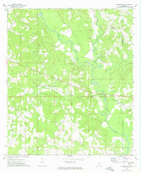
1972 Map of Pricedale
USGS Topo · Published 1974About this map
The Little Creek Oil Field dominates the northwest corner of this Mississippi landscape, illustrating the region's mid-century industrial footprint at the junction of Lincoln and Pike Counties. This 1972 survey captures the community of Pricedale as it sits near the convergence of Topisaw Creek and Carters Creek. The map provides significant genealogical value through its density of named family landmarks and rural institutions, including the McDavid, McEwen, and Bridges cemeteries, alongside numerous country churches like New Zion Ch and Spring Beulah Ch. Recreational and civic life is anchored by Felders Campground and John Felder Memorial Park, while the southern reaches follow the winding path of the Bogue Chitto, showing the area's transition from resource extraction to a established rural community network of schools like North Pike Jr High Sch.
Find a feature on this map
34 named features on this map. Tap any name to fly to it.
Don’t see what you’re looking for? This feature index may not catch every label — zoom into the map to look around manually.
Map Details
Editions of this 1972 Pricedale Map
This is the sole edition of this map. No revisions or reprints were ever made.
Other maps of this area

1953 · Natchez
USGS Topo · 1:250,000

1956 · Natchez
USGS Topo · 1:250,000

1959 · Natchez
USGS Topo · 1:250,000

1970 · Mesa
USGS Topo · 1:24,000

1970 · Topeka
USGS Topo · 1:24,000

1970 · Jayess
USGS Topo · 1:24,000

1972 · Ruth
USGS Topo · 1:24,000

1972 · Bogue Chitto
USGS Topo · 1:24,000

1972 · McComb South
USGS Topo · 1:24,000
1972 · Holmesville
USGS Topo · 1:24,000