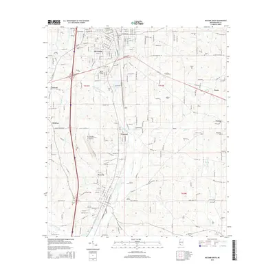
2015 Map of McComb South
USGS Topo · Published 2015About this map
The McComb and Magnolia corridor in Pike County is defined by its dense network of cemeteries and its position along the Little Tangipahoa River. In this 2015 layout, the urban grid of McComb gives way to smaller clusters like Bear Town and Fernwood, while the Minnehaha River and Bala Chitto Cr drain the surrounding piney woods. For genealogists, the map is remarkably feature-rich, documenting dozens of burial sites including the expansive Hollywood Cem, Magnolia Cem, and numerous smaller family or community plots such as Andrews Cem, Gatlin Cem, and Simmons Cem. The local aviation history is anchored by the Mc Comb/Pike County Airport/John E Lewis Field, situated north of the industrial development at Fernwood. The landscape remains a mix of established municipal centers and outlying communities like Quinlivan, Pitts, and Bacots, all linked by historical routes like Old 24 Hwy and the rail-oriented development of the river valleys.
Find a feature on this map
102 named features on this map. Tap any name to fly to it.
Don’t see what you’re looking for? This feature index may not catch every label — zoom into the map to look around manually.
Map Details
Editions of this 2015 McComb South Map
This is the sole edition of this map. No revisions or reprints were ever made.
Other maps of this area

1953 · Natchez
USGS Topo · 1:250,000

1956 · Natchez
USGS Topo · 1:250,000

1959 · Natchez
USGS Topo · 1:250,000
1972 · Osyka
USGS Topo · 1:24,000

1972 · Auburn
USGS Topo · 1:24,000

1972 · Pricedale
USGS Topo · 1:24,000

1972 · McComb South
USGS Topo · 1:24,000

1972 · Lake Tangipahoa
USGS Topo · 1:24,000
1972 · Holmesville
USGS Topo · 1:24,000
1972 · McComb North
USGS Topo · 1:24,000