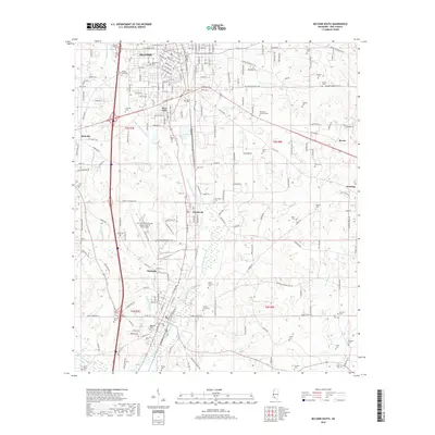
2018 Map of McComb South
USGS Topo · Published 2018About this map
Magnolia and the southern reaches of McComb serve as the primary hubs in this section of Pike County, connected by the busy corridor of the Illinois Central RR. The landscape is defined by the winding paths of the Little Tangipahoa River and Minnehaha River, which carve through the terrain alongside numerous established family and community burial grounds. For genealogists, the map is particularly rich, identifying dozens of sites such as Hollywood Cem, Ansel Prewitt Cem, and Alfred Cook Cem. Industrial and civic growth is evident in the presence of the Mc Comb/Pike County Airport/John E Lewis Field and the community of Fernwood, while smaller settlements like Bear Town and Kirkville anchor the local geography. The concentration of cemeteries throughout the rural sections suggests a deeply rooted local history and long-standing family landholdings in the region.
Find a feature on this map
202 named features on this map. Tap any name to fly to it.
Don’t see what you’re looking for? This feature index may not catch every label — zoom into the map to look around manually.
Map Details
Editions of this 2018 McComb South Map
This is the sole edition of this map. No revisions or reprints were ever made.
Other maps of this area

1953 · Natchez
USGS Topo · 1:250,000

1956 · Natchez
USGS Topo · 1:250,000

1959 · Natchez
USGS Topo · 1:250,000
1972 · Osyka
USGS Topo · 1:24,000

1972 · Auburn
USGS Topo · 1:24,000

1972 · Pricedale
USGS Topo · 1:24,000

1972 · McComb South
USGS Topo · 1:24,000

1972 · Lake Tangipahoa
USGS Topo · 1:24,000
1972 · Holmesville
USGS Topo · 1:24,000
1972 · McComb North
USGS Topo · 1:24,000