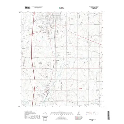
2020 Map of McComb South
USGS Topo · Published 2020About this map
The Little Tangipahoa River and Minnehaha River converge in this portion of Pike County, where the city of McComb and the town of Magnolia serve as the primary population centers. The area's mid-twentieth-century industrial and transport infrastructure is evident in the presence of the Illinois Central railroad corridor and the McComb/Pike County Airport/John E Lewis Field. Smaller settlements such as Fernwood, Bear Town, and Bacots are dispersed among a landscape punctuated by numerous family and community burial grounds. Genealogists will find a high density of sites including Hollywood Cem, Ansel Prewitt Cem, and Simmons Cem. The Pike County Courthouse stands at the heart of Magnolia, anchoring the legal and civic history of the region. This survey captures a point in time where rural agriculture and modern municipal expansion meet along the river banks and rail lines of southern Mississippi.
Find a feature on this map
188 named features on this map. Tap any name to fly to it.
Don’t see what you’re looking for? This feature index may not catch every label — zoom into the map to look around manually.
Map Details
Editions of this 2020 McComb South Map
This is the sole edition of this map. No revisions or reprints were ever made.
Other maps of this area

1953 · Natchez
USGS Topo · 1:250,000

1956 · Natchez
USGS Topo · 1:250,000

1959 · Natchez
USGS Topo · 1:250,000
1972 · Osyka
USGS Topo · 1:24,000

1972 · Auburn
USGS Topo · 1:24,000

1972 · Pricedale
USGS Topo · 1:24,000

1972 · McComb South
USGS Topo · 1:24,000

1972 · Lake Tangipahoa
USGS Topo · 1:24,000
1972 · Holmesville
USGS Topo · 1:24,000
1972 · McComb North
USGS Topo · 1:24,000