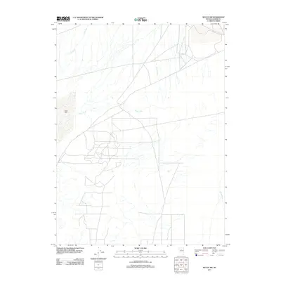
2011 Map of McCoy NW
USGS Topo · Published 2011About this map
Alkali Lake dominates the western portion of this high-desert landscape in Lander County, serving as a prominent terminal basin for the surrounding drainage systems. The hydrologic network is defined by several intermittent waterways, most notably Rock Creek, Willow Creek, and the Reese River, which thread through the basin. These watercourses and the dry lake bed illustrate the traditional drainage patterns of the Great Basin during the early 21st century. Infrastructure is sparse across this section of Nevada, primarily represented by a network of local roads and tracks including Co Rd 121, which provides access through the arid terrain. The map captures a moment in the region's recent history, documenting the land use and natural water features of this specific quadrangle as they existed in 2011.
Find a feature on this map
5 named features on this map. Tap any name to fly to it.
Don’t see what you’re looking for? This feature index may not catch every label — zoom into the map to look around manually.
Map Details
Editions of this 2011 McCoy NW Map
This is the sole edition of this map. No revisions or reprints were ever made.
Other maps of this area

1932 · Sonoma Range
USGS Topo · 1:250,000

1939 · Sonoma Range
USGS Topo · 1:250,000

1940 · Antler Peak
USGS Topo · 1:62,500

1943 · Antler Peak
USGS Topo · 1:62,500

1955 · Winnemucca
USGS Topo · 1:250,000

1958 · Winnemucca
USGS Topo · 1:250,000

1961 · McCoy
USGS Topo · 1:62,500

1962 · Winnemucca
USGS Topo · 1:250,000

1962 · Buffalo Springs
USGS Topo · 1:62,500
1965 · Cherry Creek SE
USGS Topo · 1:24,000