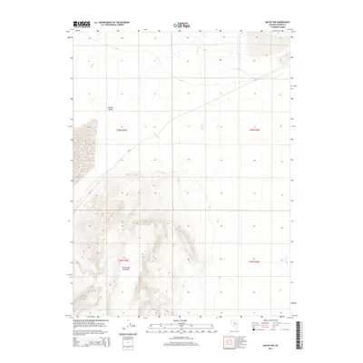
2014 Map of McCoy NW
USGS Topo · Published 2014About this map
Fish Creek Mountains dominate the southern portion of this landscape, rising sharply from the surrounding high desert basins. This 2014 survey captures the characteristic drainage patterns of the Great Basin, where seasonal watercourses like Rock Cr and Willow Cr descend into the northern reach of Buffalo Valley. To the northeast, the terrain levels out into the Alkali Flat, a feature typical of the region's arid closed-basin hydrology. The Reese River brushes the eastern edge of the quadrangle, serving as a primary water source in this sparse environment. Human presence is light, defined primarily by the corridor of CR-121 and the systematic grid of the Public Land Survey System, which divides the territory into townships including t30n r42e and t29n r43e.
Find a feature on this map
11 named features on this map. Tap any name to fly to it.
Don’t see what you’re looking for? This feature index may not catch every label — zoom into the map to look around manually.
Map Details
Editions of this 2014 McCoy NW Map
This is the sole edition of this map. No revisions or reprints were ever made.
Other maps of this area

1932 · Sonoma Range
USGS Topo · 1:250,000

1939 · Sonoma Range
USGS Topo · 1:250,000

1940 · Antler Peak
USGS Topo · 1:62,500

1943 · Antler Peak
USGS Topo · 1:62,500

1955 · Winnemucca
USGS Topo · 1:250,000

1958 · Winnemucca
USGS Topo · 1:250,000

1961 · McCoy
USGS Topo · 1:62,500

1962 · Winnemucca
USGS Topo · 1:250,000

1962 · Buffalo Springs
USGS Topo · 1:62,500
1965 · Cherry Creek SE
USGS Topo · 1:24,000