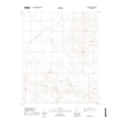
2018 Map of McCracken Peak
USGS Topo · Published 2018About this map
McCracken Peak and Aubrey Peak dominate this arid landscape within the eastern reaches of the Mojave Desert. The map documents a rugged terrain defined by the McCracken Mountains, where industrial and utility corridors provide the primary human imprint on the land. The presence of McCracken Mine Rd suggests the historical importance of mineral extraction in this remote corner of Mohave County, while the El Paso Natural Gas Pipeline Rd cuts a distinctive diagonal path across the northern reaches of Dutch Flat. Hydrological features are sparse in this environment, represented by the ephemeral Centennial Wash and the isolated Bateman Spring situated near the mountain slopes. This survey provides a precise look at the township and range divisions, such as t13n r15w, that structure this vast, undeveloped region.
Find a feature on this map
14 named features on this map. Tap any name to fly to it.
Don’t see what you’re looking for? This feature index may not catch every label — zoom into the map to look around manually.
Map Details
Editions of this 2018 McCracken Peak Map
This is the sole edition of this map. No revisions or reprints were ever made.
Other maps of this area

1923 · Signal
USGS Topo · 1:250,000

1942 · Signal
USGS Topo · 1:250,000

1950 · Prescott
USGS Topo · 1:250,000

1954 · Prescott
USGS Topo · 1:250,000

1958 · Prescott
USGS Topo · 1:250,000

1959 · Prescott
USGS Topo · 1:250,000

1960 · Prescott
USGS Topo · 1:250,000

1965 · Prescott
USGS Topo · 1:250,000
1966 · Castaneda Hills
USGS Topo · 1:62,500

1966 · Artillery Peak
USGS Topo · 1:62,500