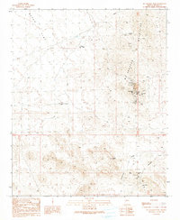
1990 Map of McCracken Peak
USGS Topo · Published 1990About this map
McCracken Mine and the surrounding peaks of the McCracken Mountains anchor this desert landscape in southern Mohave County. This 1990 provisional edition documents a rugged mining district, where dozens of labels for Prospect pits, Adits, and Mine Shafts are clustered around the high points of McCracken Peak and Aubrey Peak. This concentration of industrial activity contrasts with the broad, open expanse of Dutch Flat to the northwest, where water sources like Bateman Spring and the Sheep Mountains Well provided essential resources for life in the arid climate.
Find a feature on this map
25 named features on this map. Tap any name to fly to it.
Don’t see what you’re looking for? This feature index may not catch every label — zoom into the map to look around manually.
Map Details
Editions of this 1990 McCracken Peak Map
This is the sole edition of this map. No revisions or reprints were ever made.
Other maps of this area

1923 · Signal
USGS Topo · 1:250,000

1942 · Signal
USGS Topo · 1:250,000

1950 · Prescott
USGS Topo · 1:250,000

1954 · Prescott
USGS Topo · 1:250,000

1958 · Prescott
USGS Topo · 1:250,000

1959 · Prescott
USGS Topo · 1:250,000

1960 · Prescott
USGS Topo · 1:250,000

1965 · Prescott
USGS Topo · 1:250,000
1966 · Castaneda Hills
USGS Topo · 1:62,500

1966 · Artillery Peak
USGS Topo · 1:62,500