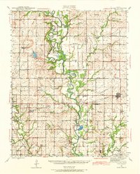
1943 Map of McCune
USGS Topo · Published 1968About this map
The Kansas Ordnance Plant dominates the southwestern landscape of this Southeast Kansas survey, illustrating the significant industrial mobilization of the World War II era across the borders of Labette and Cherokee Counties. This massive military facility, situated near the St Louis San Francisco railroad, stands in sharp contrast to the surrounding rural network of one-room schoolhouses like Stone Palace Sch and Pea Ridge Sch.
Find a feature on this map
70 named features on this map. Tap any name to fly to it.
Don’t see what you’re looking for? This feature index may not catch every label — zoom into the map to look around manually.
Map Details
Editions of this 1943 McCune Map
This is the sole edition of this map. No revisions or reprints were ever made.
Other maps of this area
1884 · Fort Scott
USGS Topo · 1:125,000

1886 · Joplin
USGS Topo · 1:125,000
1886 · Iola
USGS Topo · 1:125,000
1886 · Fort Scott
USGS Topo · 1:125,000
1886 · Parsons
USGS Topo · 1:125,000
1893 · Fort Scott
USGS Topo · 1:125,000
1893 · Iola
USGS Topo · 1:125,000
1893 · Parsons
USGS Topo · 1:125,000
1894 · Joplin
USGS Topo · 1:125,000
1904 · Iola
USGS Topo · 1:125,000