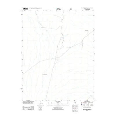
2012 Map of McCutchen Spring
USGS Topo · Published 2012About this map
McCutchen Spring and Upper McCutcheon Spring serve as critical water points in this arid expanse of Lincoln County, where the high desert terrain meets the eastern slopes of the Quinn Canyon Range. The landscape is defined by its dramatic topographic shifts, moving from the broad floor of Sand Spring Valley into the elevated terrain of the Worthington Mountains. Navigation through this area relies on a network of unpaved forest and range roads, including McCutchen Springs Rd and NFD 414 RD, which provide access to remote livestock watering sites and seasonal drainages. The presence of Cedar Spring and Wild Horse Spring underscores the traditional importance of reliable water sources for both wildlife and land management in this isolated part of Nevada, while Davis Creek marks the primary drainage system carving through the canyon slopes.
Find a feature on this map
13 named features on this map. Tap any name to fly to it.
Don’t see what you’re looking for? This feature index may not catch every label — zoom into the map to look around manually.
Map Details
Editions of this 2012 McCutchen Spring Map
This is the sole edition of this map. No revisions or reprints were ever made.
Other maps of this area

1942 · Penoyer Valley
USGS Topo · 1:125,000

1954 · Caliente
USGS Topo · 1:250,000

1956 · Lund
USGS Topo · 1:250,000

1959 · Caliente
USGS Topo · 1:250,000

1960 · Lund
USGS Topo · 1:250,000

1985 · Worthington Peak
USGS Topo · 1:24,000

1985 · McCutchen Spring
USGS Topo · 1:24,000
1985 · Goat Ranch Springs
USGS Topo · 1:24,000
1985 · Badger Gulch
USGS Topo · 1:24,000
1985 · Quinn Canyon Springs
USGS Topo · 1:24,000