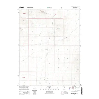
2015 Map of McCutchen Spring
USGS Topo · Published 2015About this map
McCutchen Spring and the drainage of Davis Cr characterize this portion of the high desert along the border of Nevada and Lincoln County. The northern portion of the sheet is dominated by the mountainous terrain of the Humboldt National Forest, where steep contours contrast sharply with the broad expanses of Sand Spring Valley to the south. This transition reveals a landscape defined by its scarce water sources, as shown by the network of tracks including McCutchen Spring Rd and Wild Horse Spring Rd that connect isolated watering points like Cedar Spring and Wild Horse Spring. The presence of Upper McCutchen Spring further up the slopes indicates the critical role these hydrological features play in an otherwise arid environment, dictating the placement of primitive roads such as Barney Pass Rd.
Find a feature on this map
19 named features on this map. Tap any name to fly to it.
Don’t see what you’re looking for? This feature index may not catch every label — zoom into the map to look around manually.
Map Details
Editions of this 2015 McCutchen Spring Map
This is the sole edition of this map. No revisions or reprints were ever made.
Other maps of this area

1942 · Penoyer Valley
USGS Topo · 1:125,000

1954 · Caliente
USGS Topo · 1:250,000

1956 · Lund
USGS Topo · 1:250,000

1959 · Caliente
USGS Topo · 1:250,000

1960 · Lund
USGS Topo · 1:250,000

1985 · Worthington Peak
USGS Topo · 1:24,000

1985 · McCutchen Spring
USGS Topo · 1:24,000
1985 · Goat Ranch Springs
USGS Topo · 1:24,000
1985 · Badger Gulch
USGS Topo · 1:24,000
1985 · Quinn Canyon Springs
USGS Topo · 1:24,000