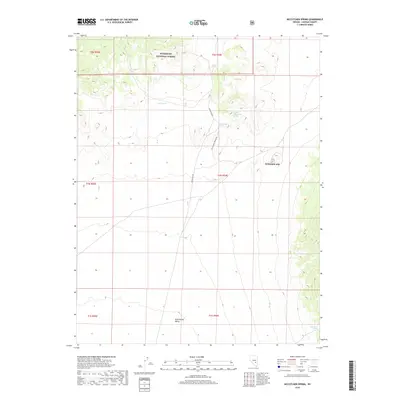
2018 Map of McCutchen Spring
USGS Topo · Published 2018About this map
Humboldt National Forest defines the northern edge of this high-desert landscape in Lincoln County, where the terrain transitions into the wide, arid expanse of Sand Spring Valley. The area is characterized by vital water sources that have long sustained activity in this remote region, including Cedar Spring, McCutchen Spring, and Upper McCutchen Spring. These points of interest are connected by primitive routes like McCutchen Rd and McCutchen Springs Rd, which trace the natural topography of the basin.
Find a feature on this map
16 named features on this map. Tap any name to fly to it.
Don’t see what you’re looking for? This feature index may not catch every label — zoom into the map to look around manually.
Map Details
Editions of this 2018 McCutchen Spring Map
This is the sole edition of this map. No revisions or reprints were ever made.
Other maps of this area

1942 · Penoyer Valley
USGS Topo · 1:125,000

1954 · Caliente
USGS Topo · 1:250,000

1956 · Lund
USGS Topo · 1:250,000

1959 · Caliente
USGS Topo · 1:250,000

1960 · Lund
USGS Topo · 1:250,000

1985 · Worthington Peak
USGS Topo · 1:24,000

1985 · McCutchen Spring
USGS Topo · 1:24,000
1985 · Goat Ranch Springs
USGS Topo · 1:24,000
1985 · Badger Gulch
USGS Topo · 1:24,000
1985 · Quinn Canyon Springs
USGS Topo · 1:24,000