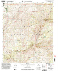
2004 Map of McDonald Mountain
USGS Topo · Published 2007About this map
Star Valley marks the northwestern edge of this landscape, where the terrain descends into the canyons of the Tonto National Forest. The map reveals a complex system of drainage and seasonal water storage essential for this arid environment, evidenced by numerous tanks like Green Valley Tank and Martin Tank. The eastern half of the survey is dominated by the Hellsgate Wilderness, a name that reflects the difficult topography found near Hellsgate and the steep cuts of Corral Canyon. This area is characterized by isolated peaks and high ridges, including Wolverton Mountain and McDonald Mountain. Throughout the forest, the map documents numerous pockets and basins such as Derrick Pocket and Brushy Basin, alongside established springs like Cottonwood Spring and Pocket Spring.
Find a feature on this map
57 named features on this map. Tap any name to fly to it.
Don’t see what you’re looking for? This feature index may not catch every label — zoom into the map to look around manually.
Map Details
Editions of this 2004 McDonald Mountain Map
This is the sole edition of this map. No revisions or reprints were ever made.
Other maps of this area

1887 · Verde
USGS Topo · 1:250,000

1892 · Verde
USGS Topo · 1:250,000

1934 · Pine
USGS Topo · 1:62,500

1934 · Promontory Butte
USGS Topo · 1:62,500

1936 · Payson
USGS Topo · 1:48,000

1937 · Diamond Butte
USGS Topo · 1:48,000

1939 · Promontory Butte
USGS Topo · 1:62,500

1940 · Pine
USGS Topo · 1:62,500

1942 · Payson
USGS Topo · 1:62,500

1943 · Diamond Butte
USGS Topo · 1:62,500