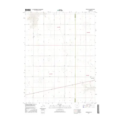
2015 Map of McDonald SW
USGS Topo · Published 2015About this map
McDonald sits near the eastern edge of this agricultural landscape in Rawlins County, situated just above the headwaters of N Beaver Cr. The map reveals a strictly organized rural grid system, defined by thoroughfares such as Co Line Rd and Co Rd 32, which segment the prairie into large sections. Genealogy researchers can identify local burial sites at Evergreen Cem and Grace Cem, the latter located just west of the town center. The terrain is characterized by the high plains of western Kansas, where the transition between Cheyenne Co and Rawlins Co is marked by a simple straight-line political boundary. The layout of the roads and the placement of small cemeteries relative to the primary settlement illustrate the traditional land use patterns of this grain-growing region.
Find a feature on this map
25 named features on this map. Tap any name to fly to it.
Don’t see what you’re looking for? This feature index may not catch every label — zoom into the map to look around manually.
Map Details
Editions of this 2015 McDonald SW Map
This is the sole edition of this map. No revisions or reprints were ever made.
Other maps of this area

1950 · Mc Donald
USGS Topo · 1:62,500

1951 · Bird City North
USGS Topo · 1:62,500

1951 · Mc Donald
USGS Topo · 1:62,500

1951 · Bird City South
USGS Topo · 1:62,500

1951 · Dewey Ranch
USGS Topo · 1:62,500

1954 · Goodland
USGS Topo · 1:250,000

1956 · Goodland
USGS Topo · 1:250,000

1957 · Goodland
USGS Topo · 1:250,000

1976 · Bird City North
USGS Topo · 1:24,000
1976 · Henkle Canyon
USGS Topo · 1:24,000