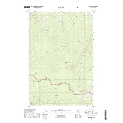
2020 Map of McGee Peak
USGS Topo · Published 2020About this map
Lolo National Forest and St. Joe National Forest meet along the high ridges of the Bitterroot Range in this 2020 terrain study. This high-elevation landscape is defined by its drainage systems, where the headwaters of Big Creek and its various forks carve through the granite of Shoshone County. Names such as Glitter, Coronary, and Aorta mark specific points of interest, likely reflecting the area's prospecting and mining heritage. The map details a network of forest roads, including Big Creek Rd and Nat For Dev Rd 391, which provide access to high-mountain basins containing Heart Lake, Crystal Lake, and Gold Lake. Topographic prominence is found at McGee Peak and Ward Peak, which anchor the divide between the Montana and Idaho state line.
Find a feature on this map
84 named features on this map. Tap any name to fly to it.
Don’t see what you’re looking for? This feature index may not catch every label — zoom into the map to look around manually.
Map Details
Editions of this 2020 McGee Peak Map
This is the sole edition of this map. No revisions or reprints were ever made.
Other maps of this area

1914 · Avery
USGS Topo · 1:125,000

1917 · Avery
USGS Topo · 1:125,000

1918 · St Regis
USGS Topo · 1:125,000

1919 · St. Regis
USGS Topo · 1:125,000

1956 · Saltese
USGS Topo · 1:62,500

1956 · Wallace
USGS Topo · 1:250,000

1957 · Haugan
USGS Topo · 1:62,500

1957 · Simmons Peak
USGS Topo · 1:62,500

1960 · Wallace
USGS Topo · 1:250,000
1969 · Thor Mountain
USGS Topo · 1:24,000