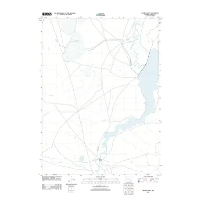
2012 Map of McGill Lakes
USGS Topo · Published 2012About this map
The Laramie River winds through this high-plains landscape in Albany County, anchoring a network of water management features and ranching interests. The eastern portion of the sheet is dominated by the sprawling expanse of Wheatland Reservoir Number 2, while Wheatland Reservoir Number 3 and the McGill Lakes occupy the northwestern corner. This 2012 survey illustrates the vital importance of water storage in the Wyoming interior, showing the intricate relationship between natural drainage and man-made reservoirs. Local landmarks like Kite Ranch and the McGill Bridge indicate the sparse but established human presence in the region. The map also traces the paths of Spring Cr and S Fork Spring Cr as they feed into the larger hydrologic system, while Round Top Rd provides the primary overland transit through this expansive basin.
Find a feature on this map
10 named features on this map. Tap any name to fly to it.
Don’t see what you’re looking for? This feature index may not catch every label — zoom into the map to look around manually.
Map Details
Editions of this 2012 McGill Lakes Map
This is the sole edition of this map. No revisions or reprints were ever made.
Other maps of this area

1954 · Cheyenne
USGS Topo · 1:250,000

1955 · Mc Gill Lakes
USGS Topo · 1:24,000

1955 · Dodge Ranch
USGS Topo · 1:24,000

1955 · Bluegrass Wells
USGS Topo · 1:24,000

1955 · Sevenmile Spring
USGS Topo · 1:24,000

1955 · Sybille Springs
USGS Topo · 1:24,000

1955 · Ayres Spring
USGS Topo · 1:24,000

1955 · Cooper Lake North
USGS Topo · 1:24,000

1955 · Lake Ione
USGS Topo · 1:24,000

1955 · Cannonball Cut
USGS Topo · 1:24,000