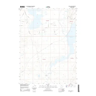
2015 Map of McGill Lakes
USGS Topo · Published 2015About this map
The Laramie River winds through this high-plains landscape in Albany County, defining a complex riparian system that includes McGill Lakes and the expansive Wheatland Reservoir Number Two. This 2015 survey reveals a terrain shaped by water management and historic transit routes, most notably the Old Fort Fetterman Rd and Fetterman Rd, which track the high ground west of the river. Small water bodies like Post Lake, Twin Lakes, and the drainage of Spring Cr create a network of wetlands and seasonal flows across the northern and southern sections. The map shows a transition from historical trail corridors to modern rural infrastructure, anchored by the McGill Bridge crossing. Residential or ranch access is marked by an extensive grid of local roads with names like Sabel Palm Dr and High Plains Rd, illustrating the modern development patterns around these water features.
Find a feature on this map
32 named features on this map. Tap any name to fly to it.
Don’t see what you’re looking for? This feature index may not catch every label — zoom into the map to look around manually.
Map Details
Editions of this 2015 McGill Lakes Map
This is the sole edition of this map. No revisions or reprints were ever made.
Other maps of this area
1954 · Cheyenne
USGS Topo · 1:250,000
1955 · Mc Gill Lakes
USGS Topo · 1:24,000
1955 · Dodge Ranch
USGS Topo · 1:24,000
1955 · Bluegrass Wells
USGS Topo · 1:24,000
1955 · Sevenmile Spring
USGS Topo · 1:24,000
1955 · Sybille Springs
USGS Topo · 1:24,000
1955 · Ayres Spring
USGS Topo · 1:24,000
1955 · Cooper Lake North
USGS Topo · 1:24,000
1955 · Lake Ione
USGS Topo · 1:24,000
1955 · Cannonball Cut
USGS Topo · 1:24,000