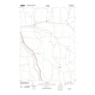
2010 Map of McGraw
USGS Topo · Published 2010About this map
McGraw and the nearby hamlet of Maybury Mills anchor this Central New York landscape, where the terrain transitions from the valley of the Tioughnioga River to the upland plateaus of South Hill and Underwood Hill. The map reveals a persistent rural settlement pattern defined by creek-valley roads and family-named elevations like Hicks Hill and Snyder Hill. Genealogists will find a high concentration of burial sites, including the McGrawville Rural Cemetery, Maplewood Cemetery, and Turner Cemetery, reflecting the area's long agricultural history. In the southern portion of the quadrangle, the rugged topography of Hoxie Gorge stands in contrast to the developed crossroads at Freetown Corners. The hydrology is dominated by the westward-flowing Trout Brook and Smith Brook, which carved the valleys that dictated early road placements such as Clinton St and McGraw North Rd.
Find a feature on this map
60 named features on this map. Tap any name to fly to it.
Don’t see what you’re looking for? This feature index may not catch every label — zoom into the map to look around manually.
Map Details
Editions of this 2010 McGraw Map
This is the sole edition of this map. No revisions or reprints were ever made.
Other maps of this area

1903 · Cortland
USGS Topo · 1:62,500

1903 · Harford
USGS Topo · 1:62,500

1904 · Greene
USGS Topo · 1:62,500

1904 · Pitcher
USGS Topo · 1:62,500

1906 · Catatonk
USGS Topo · 1:125,000

1943 · Cincinnatus
USGS Topo · 1:24,000

1943 · Cuyler
USGS Topo · 1:24,000
1944 · Homer
USGS Topo · 1:31,680

1944 · Cortland
USGS Topo · 1:31,680
1944 · Cuyler
USGS Topo · 1:31,680