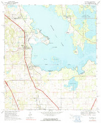
1968 Map of McIntosh
USGS Topo · Published 1990About this map
The town of McIntosh stands on the western shore of Orange Lake, serving as a focal point for this 1960s survey of the north-central Florida lake country. This landscape is defined by its vast wetlands and prairies, including Fish Prairie to the northwest and Hawthorn Prairie to the southeast, separated by the sprawling waters of the lake. Historical land divisions are clearly marked by the Arredondo Grant boundary, which cuts through the water and wetlands, reflecting the region's Spanish colonial era heritage.
Find a feature on this map
36 named features on this map. Tap any name to fly to it.
Don’t see what you’re looking for? This feature index may not catch every label — zoom into the map to look around manually.
Map Details
Editions of this 1968 McIntosh Map
3 editions found
Other maps of this area

1890 · Arredondo
USGS Topo · 1:62,500

1892 · Arredondo
USGS Topo · 1:62,500

1893 · Citra
USGS Topo · 1:62,500

1894 · Arredondo
USGS Topo · 1:62,500

1895 · Williston
USGS Topo · 1:62,500

1895 · Citra
USGS Topo · 1:62,500

1938 · Hawthorn
USGS Topo · 1:48,000

1943 · Hawthorn
USGS Topo · 1:62,500

1954 · Gainesville
USGS Topo · 1:250,000

1958 · Gainesville
USGS Topo · 1:250,000