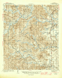
1944 Map of McIntosh
USGS Topo · Published 1944About this map
McIntosh and the surrounding piney woods of Washington County are documented here during the mid-1940s, revealing a landscape defined by small rural settlements and a network of logging and transport routes. The Southern railroad line runs parallel to the Mobile River, connecting communities like Sunflower, Cortelyou, and Wagarville. Further west, the Chatom Road and Tennessee Road cut through a terrain of numerous creeks and swamps, including the colorfully named Bull Hell Swamp and Calf Pasture Swamp.
Find a feature on this map
64 named features on this map. Tap any name to fly to it.
Don’t see what you’re looking for? This feature index may not catch every label — zoom into the map to look around manually.
Map Details
Editions of this 1944 McIntosh Map
2 editions found
Other maps of this area

1942 · Deer Park
USGS Topo · 1:62,500

1943 · Deer Park
USGS Topo · 1:62,500

1943 · Choctaw Bluff
USGS Topo · 1:62,500

1943 · Tensaw
USGS Topo · 1:62,500

1943 · Citronelle
USGS Topo · 1:62,500

1943 · McIntosh
USGS Topo · 1:62,500

1944 · McIntosh
USGS Topo · 1:62,500

1944 · Tensaw
USGS Topo · 1:62,500

1946 · Citronelle
USGS Topo · 1:62,500

1946 · Choctaw Bluff
USGS Topo · 1:62,500