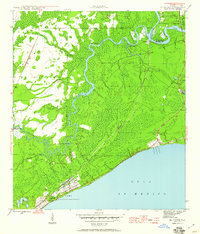
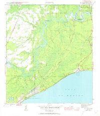
1945 Map of McIntyre
USGS Topo · Published 1960About this map
Camp Gordon Johnson dominates the coastline of this mid-1940s survey, marking a significant period of military activity along the Gulf of Mexico. This expansive installation, connected by the Military Road, contrasts with the winding, natural waterways that define the inland geography. The Ochlockonee River and Crooked River snake through a landscape characterized by wet forests and low-lying bluffs, such as Lewis Bluff and Davis Bluff.
Find a feature on this map
21 named features on this map. Tap any name to fly to it.
Don’t see what you’re looking for? This feature index may not catch every label — zoom into the map to look around manually.
Map Details
Editions of this 1945 McIntyre Map
6 editions found
Other maps of this area

1940 · Arran
USGS Topo · 1:62,500

1943 · Arran
USGS Topo · 1:62,500

1943 · Dog Island
USGS Topo · 1:31,680

1943 · Carrabelle
USGS Topo · 1:24,000

1943 · St. Teresa Beach
USGS Topo · 1:24,000

1944 · Pickett Bay
USGS Topo · 1:31,680

1944 · Carrabelle
USGS Topo · 1:31,680

1945 · Thousand Yard Bay
USGS Topo · 1:31,680

1945 · Mc Intyre
USGS Topo · 1:31,680

1945 · St Teresa
USGS Topo · 1:31,680