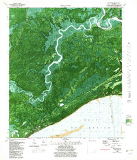
1982 Map of McIntyre
USGS Topo · Published 1982About this map
The Ochlockonee River and Crooked River wind through the dense swamp and forest of the Florida Panhandle on this 1982 orthophotomap. The landscape is dominated by the Apalachicola National Forest, where the junction of Franklin and Wakulla counties is marked by the settlement of McIntyre. The map provides a unique visual record of the coastline along the Gulf of Mexico, including the sand bars of Lanark Reef and the prominent Pelican Lump. Significant infrastructure for research and safety is visible, including the Florida State Univ Marine Laboratory and the St James Fire Tower. Historical river access points like Rock Landing, Lewis Bluff, and Blackjack Landing highlight the importance of these waterways for interior transport. The transition from the developed coastal strip at Lanark Village to the uninhabited wetlands illustrates the distinct environmental zones of this Gulf Coast region.
Find a feature on this map
27 named features on this map. Tap any name to fly to it.
Don’t see what you’re looking for? This feature index may not catch every label — zoom into the map to look around manually.
Map Details
Editions of this 1982 McIntyre Map
Other maps of this area

1940 · Arran
USGS Topo · 1:62,500

1943 · Arran
USGS Topo · 1:62,500

1943 · Dog Island
USGS Topo · 1:31,680

1943 · Carrabelle
USGS Topo · 1:24,000

1943 · St. Teresa Beach
USGS Topo · 1:24,000

1944 · Pickett Bay
USGS Topo · 1:31,680

1944 · Carrabelle
USGS Topo · 1:31,680

1945 · Thousand Yard Bay
USGS Topo · 1:31,680

1945 · Mc Intyre
USGS Topo · 1:31,680

1945 · St Teresa
USGS Topo · 1:31,680