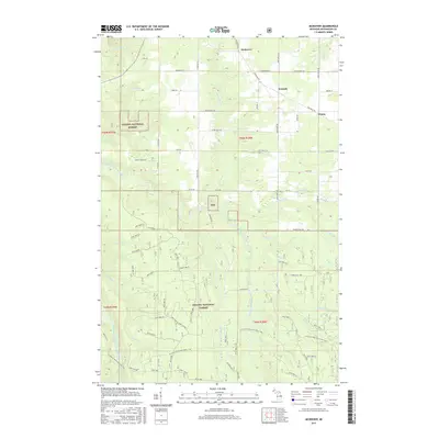
2017 Map of McKeever
USGS Topo · Published 2017About this map
The Ottawa National Forest blankets much of this area within the western Upper Peninsula, where timber and water resources define the local geography. Small settlements like McKeever, Wainola, and Wasas are connected by a network of rural roads such as Rousseau Rd and Simar Wasas Rd, reflecting the Finnish heritage of many early Ontonagon County settlers. The landscape is deeply incised by the East Branch and Middle Branch Ontonagon River, including the distinctive Three Rapids. Numerous tributaries like Adventure Cr, Bond Cr, and Flintsteel River weave through the forest, illustrating the complex hydrology that supported the region's historic mining and logging interests. Modern forestry management is evident through a series of Forest Service roads, including Nfst-866, which provide access to the interior of the woodland.
Find a feature on this map
79 named features on this map. Tap any name to fly to it.
Don’t see what you’re looking for? This feature index may not catch every label — zoom into the map to look around manually.
Map Details
Editions of this 2017 McKeever Map
This is the sole edition of this map. No revisions or reprints were ever made.
Other maps of this area
1949 · Rockland
USGS Topo · 1:62,500
1950 · Greenland
USGS Topo · 1:62,500
1951 · Rockland
USGS Topo · 1:62,500
1951 · Greenland
USGS Topo · 1:62,500
1954 · Rousseau
USGS Topo · 1:62,500
1954 · Winona
USGS Topo · 1:62,500
1958 · Iron River
USGS Topo · 1:250,000
1960 · Iron River
USGS Topo · 1:250,000
1961 · Iron River
USGS Topo · 1:250,000
1967 · Iron River
USGS Topo · 1:250,000