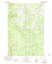
1982 Map of McKeever
USGS Topo · Published 1983About this map
The Escanaba and Lake Superior railroad corridor anchors this remote landscape in Ontonagon County during the late 1970s. The tracks weave through the northern timberlands, connecting the small settlements of Mass Station, McKeever, Wainola, and Wasas. The area is defined by its complex drainage network, where the East Branch Ontonagon River and Middle Branch Ontonagon River converge amidst the protected boundaries of the Ottawa National Forest. Local community life is marked by the Wainola Ch and various family-named landmarks like Wasas and Wainola. Notable water features such as Adventure Creek and Flintsteel River cut through the terrain, while the southern reach of the map features the distinct Three Rapids. This survey captures a moment when traditional rail infrastructure remained central to the transit of timber and materials through Michigan's Upper Peninsula.
Find a feature on this map
31 named features on this map. Tap any name to fly to it.
Don’t see what you’re looking for? This feature index may not catch every label — zoom into the map to look around manually.
Map Details
Editions of this 1982 McKeever Map
This is the sole edition of this map. No revisions or reprints were ever made.
Other maps of this area

1949 · Rockland
USGS Topo · 1:62,500

1950 · Greenland
USGS Topo · 1:62,500

1951 · Rockland
USGS Topo · 1:62,500

1951 · Greenland
USGS Topo · 1:62,500

1954 · Rousseau
USGS Topo · 1:62,500

1954 · Winona
USGS Topo · 1:62,500

1958 · Iron River
USGS Topo · 1:250,000

1960 · Iron River
USGS Topo · 1:250,000

1961 · Iron River
USGS Topo · 1:250,000

1967 · Iron River
USGS Topo · 1:250,000