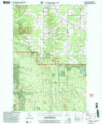
1999 Map of McKeever
USGS Topo · Published 2004About this map
The East Branch Ontonagon River carves through the heart of this Upper Peninsula landscape, marking a terrain defined by heavy timber and a network of tributary creeks. Within the Ottawa National Forest, the small settlements of McKeever, Wainola, and Wasas represent the localized human footprint during the late twentieth century. Transportation and utility patterns are evidenced by the Mass Station and a Gaging Sta along the riverbanks, while the presence of the North Country National Scenic Trail winding through the southern portion highlights the region's significance for modern outdoor recreation. The map also documents local infrastructure such as the Wainola Ch and a secluded Landing Strip, providing a look at how these remote communities in Greenland and Rockland townships maintained connectivity and social centers.
Find a feature on this map
27 named features on this map. Tap any name to fly to it.
Don’t see what you’re looking for? This feature index may not catch every label — zoom into the map to look around manually.
Map Details
Editions of this 1999 McKeever Map
This is the sole edition of this map. No revisions or reprints were ever made.
Other maps of this area

1949 · Rockland
USGS Topo · 1:62,500

1950 · Greenland
USGS Topo · 1:62,500

1951 · Rockland
USGS Topo · 1:62,500

1951 · Greenland
USGS Topo · 1:62,500

1954 · Rousseau
USGS Topo · 1:62,500

1954 · Winona
USGS Topo · 1:62,500

1958 · Iron River
USGS Topo · 1:250,000

1960 · Iron River
USGS Topo · 1:250,000

1961 · Iron River
USGS Topo · 1:250,000

1967 · Iron River
USGS Topo · 1:250,000