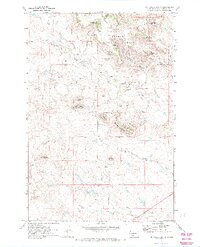
1971 Map of McKenzie Butte
USGS Topo · Published 1974About this map
Custer National Forest encompasses much of this northwestern South Dakota landscape, where the South Cave Hills rise above a network of gulches and canyons. The 1971 survey documents a remote ranching and resource-extraction area centered around the Jones settlement. Several family-named landmarks such as John Brown Spring No 2, Penttila Butte, and Van Offern Butte indicate the importance of water sources and high-ground navigation to local homesteaders and landholders.
Find a feature on this map
29 named features on this map. Tap any name to fly to it.
Don’t see what you’re looking for? This feature index may not catch every label — zoom into the map to look around manually.
Map Details
Editions of this 1971 McKenzie Butte Map
2 editions found
Other maps of this area

1935 · Reva
USGS Topo · 1:125,000

1935 · Buffalo
USGS Topo · 1:125,000

1954 · Lemmon
USGS Topo · 1:250,000

1957 · Lemmon
USGS Topo · 1:250,000

1968 · Ludlow
USGS Topo · 1:24,000

1969 · Ladner
USGS Topo · 1:24,000

1969 · Ladner SE
USGS Topo · 1:24,000

1971 · Buffalo
USGS Topo · 1:24,000
1971 · Lahti Butte
USGS Topo · 1:24,000

1971 · McKenzie Butte
USGS Topo · 1:24,000