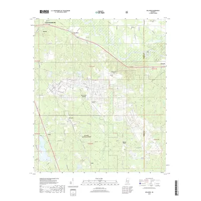
2018 Map of McLaurin
USGS Topo · Published 2018About this map
MTA Camp Shelby dominates the central landscape of this Forrest County region, showing a dense network of military infrastructure including Jackson Ave, Forrest Ave, and the Hagler Army Heliport. This southern Mississippi territory, situated just south of Hattiesburg, transitions from the structured grid of the military installation into the wooded reaches of the De Soto National Forest. To the north, the Leaf River meanders through a series of oxbows and named lakes such as Quickswipe Lake, Harry Lake, and Blue Lake, illustrating the complex hydrology of the river basin. Several small settlements and family-named landmarks are scattered throughout, including McLaurin, McCallum, and Epps, alongside numerous historic burial grounds like McKenzie-Myers Cem and Garraway Cem. The presence of the Shelby Auxiliary Field One Airport further emphasizes the area's long-standing connection to aviation and military training.
Find a feature on this map
79 named features on this map. Tap any name to fly to it.
Don’t see what you’re looking for? This feature index may not catch every label — zoom into the map to look around manually.
Map Details
Editions of this 2018 McLaurin Map
This is the sole edition of this map. No revisions or reprints were ever made.
Other maps of this area

1947 · New Augusta
USGS Topo · 1:62,500

1949 · New Augusta
USGS Topo · 1:62,500

1953 · Hattiesburg
USGS Topo · 1:250,000

1958 · Hattiesburg
USGS Topo · 1:250,000

1963 · Rock Hill
USGS Topo · 1:24,000

1964 · Carterville
USGS Topo · 1:24,000

1964 · Ovett SE
USGS Topo · 1:24,000

1964 · Hattiesburg
USGS Topo · 1:24,000

1965 · Dixie
USGS Topo · 1:24,000
1983 · McLaurin
USGS Topo · 1:24,000