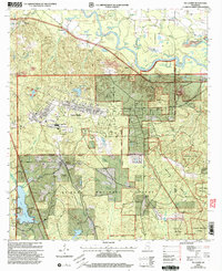
2000 Map of McLaurin
USGS Topo · Published 2003About this map
Camp Shelby dominates the landscape south of the Leaf River, reflecting the heavy military presence in this portion of the De Soto National Forest at the turn of the 21st century. The map documents a complex infrastructure of training grounds, including a Dedicated Impact Area (Danger) and the Hagler AAF Airport. Outside the military reservation, small settlements like McLaurin and McCallum persist along the road and rail corridors.
Find a feature on this map
53 named features on this map. Tap any name to fly to it.
Don’t see what you’re looking for? This feature index may not catch every label — zoom into the map to look around manually.
Map Details
Editions of this 2000 McLaurin Map
This is the sole edition of this map. No revisions or reprints were ever made.
Other maps of this area

1947 · New Augusta
USGS Topo · 1:62,500

1949 · New Augusta
USGS Topo · 1:62,500

1953 · Hattiesburg
USGS Topo · 1:250,000

1958 · Hattiesburg
USGS Topo · 1:250,000

1963 · Rock Hill
USGS Topo · 1:24,000

1964 · Carterville
USGS Topo · 1:24,000

1964 · Ovett SE
USGS Topo · 1:24,000

1964 · Hattiesburg
USGS Topo · 1:24,000

1965 · Dixie
USGS Topo · 1:24,000
1983 · McLaurin
USGS Topo · 1:24,000