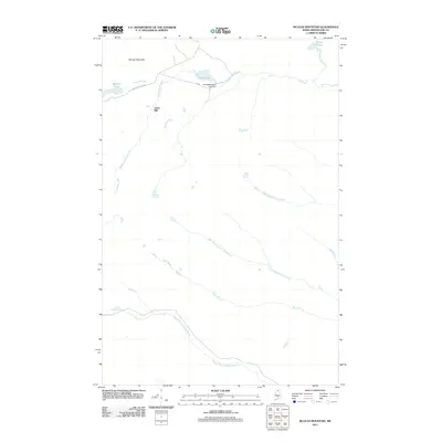
2011 Map of McLean Mountain
USGS Topo · Published 2011About this map
McLean Mountain dominates the northern landscape of this Aroostook County terrain, serving as a high-altitude anchor for a complex network of waterways in northern Maine. The map reveals a specific industrial and timber-focused geography, centered on the Third Wallagrass Lake Dam and the settlement at Jones Mill. This area is defined by its drainage patterns, where Wallagrass Stream and the North Branch Birch River carve through the wooded interior. Local infrastructure is minimal, represented by the Pelletier Lakes Rd winding toward the basin of McLean Lake and Third Lake. Further east, the Gilbert Ponds and Gilbert Brook reflect the undisturbed water systems typical of the Maine North Woods before reaching the southern tributaries of Black Brook and the North Branch Rocky Brook.
Find a feature on this map
14 named features on this map. Tap any name to fly to it.
Don’t see what you’re looking for? This feature index may not catch every label — zoom into the map to look around manually.
Map Details
Editions of this 2011 McLean Mountain Map
This is the sole edition of this map. No revisions or reprints were ever made.
Other maps of this area

1928 · Eagle Lake
USGS Topo · 1:48,000

1928 · Winterville
USGS Topo · 1:48,000

1930 · St Francis
USGS Topo · 1:48,000

1931 · Fish River Lake
USGS Topo · 1:48,000

1931 · Eagle Lake
USGS Topo · 1:62,500

1931 · Winterville
USGS Topo · 1:62,500

1933 · St Francis
USGS Topo · 1:62,500

1935 · Fish River Lake
USGS Topo · 1:62,500

1954 · Presque Isle
USGS Topo · 1:250,000

1958 · Presque Isle
USGS Topo · 1:250,000