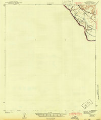
1943 Map of McNary
USGS Topo · Published 1943About this map
The Rio Grande defines the international boundary and the agricultural landscape of this corner of west Texas during the early 1940s. Centered on the settlement of McNary, the map reveals an intricate network of irrigation infrastructure essential for desert farming, including the Hudspeth Main Canal, the Diablo Canal, and the Algodon Canal. These man-made waterways contrast with the natural ephemeral drainages of Madden Arroyo and Diablo Arroyo that cut toward the river valley. The corridor is a vital transportation artery, where the Southern Pacific and Texas And Pacific rail lines parallel the river, supporting local agricultural hubs like Camp 9 and the Hudspeth Farm Camp. This survey captures the intensive land use in the river bottomlands just before the era of major mid-century agricultural shifts.
Find a feature on this map
17 named features on this map. Tap any name to fly to it.
Don’t see what you’re looking for? This feature index may not catch every label — zoom into the map to look around manually.
Map Details
Editions of this 1943 McNary Map
This is the sole edition of this map. No revisions or reprints were ever made.
Other maps of this area

1894 · Fort Hancock
USGS Topo · 1:125,000

1896 · Rio Grande
USGS Topo · 1:125,000

1941 · Tornillo
USGS Topo · 1:62,500

1943 · Fort Quitman
USGS Topo · 1:62,500

1943 · Finlay Mountains
USGS Topo · 1:62,500

1943 · Fort Hancock
USGS Topo · 1:62,500
1945 · Tornillo
USGS Topo · 1:62,500

1953 · El Paso
USGS Topo · 1:250,000

1954 · Van Horn
USGS Topo · 1:250,000

1958 · Van Horn
USGS Topo · 1:250,000